|
|
|||||||||||||||||
| Point ID: 3619 | Downloads | Plots | Site Data | Other Close Sites | Code: 10GB001 |
|
|
|||||||||||||||||
| Download | |
|---|---|
| Site Descriptor Information | Site Time Series Data |
| Link to all available data | |
| View: | Time Series | All |
| Units: | mm |
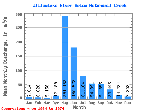
| Statistic | Jan | Feb | Mar | Apr | May | Jun | Jul | Aug | Sep | Oct | Nov | Dec | Annual |
|---|---|---|---|---|---|---|---|---|---|---|---|---|---|
| Mean | 7.61 | 6.03 | 5.16 | 12.19 | 291.18 | 180.57 | 81.16 | 54.39 | 51.85 | 33.45 | 14.22 | 9.30 | 62.26 |
| Standard Deviation | 3.83 | 2.63 | 1.94 | 19.19 | 124.34 | 47.11 | 42.90 | 39.20 | 38.26 | 23.79 | 7.50 | 4.55 | 11.64 |
| Min | 3.05 | 3.12 | 2.32 | 2.35 | 111.00 | 98.30 | 36.50 | 19.80 | 18.80 | 14.30 | 4.38 | 4.68 | 41.27 |
| Max | 14.90 | 12.00 | 9.26 | 69.20 | 510.00 | 263.00 | 199.00 | 164.00 | 138.00 | 96.80 | 30.50 | 19.30 | 85.28 |
| Coefficient of Variation | 0.50 | 0.44 | 0.38 | 1.57 | 0.43 | 0.26 | 0.53 | 0.72 | 0.74 | 0.71 | 0.53 | 0.49 | 0.19 |
| Other Close Sites | ||||||
|---|---|---|---|---|---|---|
| PointID | Latitude | Longitude | Drainage Area | Source | Name | |
| 3621 | "WILLOWLAKE RIVER ABOVE METAHDALI CREEK" | 62.65 | 1635870 | Hydat | ||
 Return to R-Arctic Net Home Page