|
|
|||||||||||||||||
| Point ID: 9735 | Downloads | Plots | Site Data | Code: 05082500 |
|
|
|||||||||||||||||
| Download | |
|---|---|
| Site Descriptor Information | Site Time Series Data |
| Link to all available data | |
| View: | Time Series | All |
| Units: | mm |
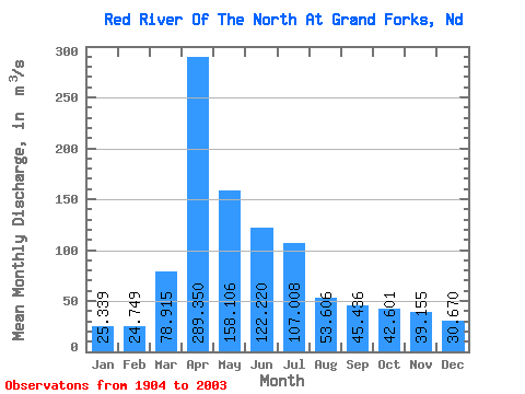
| Statistic | Jan | Feb | Mar | Apr | May | Jun | Jul | Aug | Sep | Oct | Nov | Dec | Annual |
|---|---|---|---|---|---|---|---|---|---|---|---|---|---|
| Mean | 25.34 | 24.75 | 78.92 | 289.35 | 158.11 | 122.22 | 107.01 | 53.61 | 45.44 | 42.60 | 39.16 | 30.67 | 84.93 |
| Standard Deviation | 17.90 | 18.45 | 86.17 | 270.49 | 159.86 | 98.00 | 117.16 | 61.76 | 45.18 | 33.50 | 36.92 | 23.32 | 59.09 |
| Min | 0.53 | 0.08 | 1.19 | 27.02 | 10.57 | 4.27 | 2.52 | 0.87 | 0.58 | 0.34 | 0.86 | 0.50 | 6.90 |
| Max | 75.22 | 99.67 | 435.18 | 1591.68 | 1033.93 | 547.65 | 715.68 | 482.89 | 321.08 | 145.17 | 282.35 | 108.52 | 291.36 |
| Coefficient of Variation | 0.71 | 0.75 | 1.09 | 0.94 | 1.01 | 0.80 | 1.09 | 1.15 | 0.99 | 0.79 | 0.94 | 0.76 | 0.70 |
 Return to R-Arctic Net Home Page