|
|
|||||||||||||||||
| Point ID: 9735 | Downloads | Plots | Site Data | Code: 05082500 |
|
|
|||||||||||||||||
| Download | |
|---|---|
| Site Descriptor Information | Site Time Series Data |
| Link to all available data | |
| View: | Time Series | All |
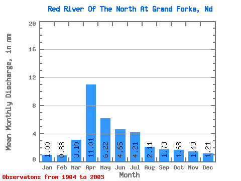
| Units: | m3/s |
| Statistic | Jan | Feb | Mar | Apr | May | Jun | Jul | Aug | Sep | Oct | Nov | Dec | Annual |
|---|---|---|---|---|---|---|---|---|---|---|---|---|---|
| Mean | 0.87 | 0.78 | 2.71 | 9.62 | 5.43 | 4.06 | 3.68 | 1.84 | 1.51 | 1.46 | 1.30 | 1.05 | 34.38 |
| Standard Deviation | 0.61 | 0.58 | 2.96 | 8.99 | 5.49 | 3.26 | 4.02 | 2.12 | 1.50 | 1.15 | 1.23 | 0.80 | 23.92 |
| Min | 0.02 | 0.00 | 0.04 | 0.90 | 0.36 | 0.14 | 0.09 | 0.03 | 0.02 | 0.01 | 0.03 | 0.02 | 2.79 |
| Max | 2.58 | 3.12 | 14.95 | 52.92 | 35.52 | 18.21 | 24.59 | 16.59 | 10.68 | 4.99 | 9.39 | 3.73 | 117.95 |
| Coefficient of Variation | 0.71 | 0.75 | 1.09 | 0.94 | 1.01 | 0.80 | 1.09 | 1.15 | 0.99 | 0.79 | 0.94 | 0.76 | 0.70 |
 Return to R-Arctic Net Home Page