|
|
|||||||||||||||||
| Point ID: 9728 | Downloads | Plots | Site Data | Code: 05062500 |
|
|
|||||||||||||||||
| Download | |
|---|---|
| Site Descriptor Information | Site Time Series Data |
| Link to all available data | |
| View: | Time Series | All |
| Units: | mm |
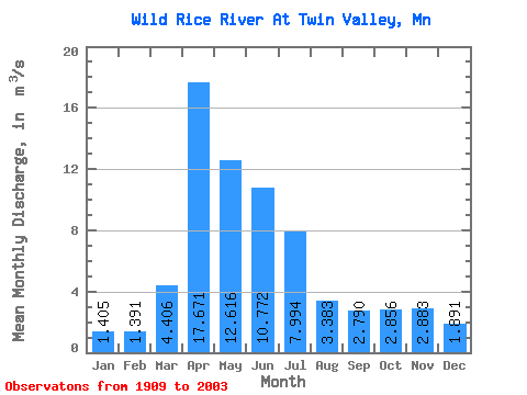
| Statistic | Jan | Feb | Mar | Apr | May | Jun | Jul | Aug | Sep | Oct | Nov | Dec | Annual |
|---|---|---|---|---|---|---|---|---|---|---|---|---|---|
| Mean | 1.41 | 1.39 | 4.41 | 17.67 | 12.62 | 10.77 | 7.99 | 3.38 | 2.79 | 2.86 | 2.88 | 1.89 | 5.84 |
| Standard Deviation | 1.10 | 1.37 | 4.83 | 14.23 | 9.79 | 13.45 | 10.64 | 5.12 | 4.16 | 2.98 | 3.63 | 1.68 | 3.74 |
| Min | 0.11 | 0.11 | 0.36 | 2.09 | 0.87 | 0.75 | 0.23 | 0.09 | 0.05 | 0.17 | 0.26 | 0.17 | 0.76 |
| Max | 5.68 | 9.50 | 23.45 | 69.97 | 63.98 | 97.44 | 54.54 | 28.98 | 23.85 | 17.37 | 26.66 | 9.72 | 18.29 |
| Coefficient of Variation | 0.78 | 0.98 | 1.10 | 0.81 | 0.78 | 1.25 | 1.33 | 1.51 | 1.49 | 1.04 | 1.26 | 0.89 | 0.64 |
 Return to R-Arctic Net Home Page