|
|
|||||||||||||||||
| Point ID: 9728 | Downloads | Plots | Site Data | Code: 05062500 |
|
|
|||||||||||||||||
| Download | |
|---|---|
| Site Descriptor Information | Site Time Series Data |
| Link to all available data | |
| View: | Time Series | All |
| Units: | m3/s |
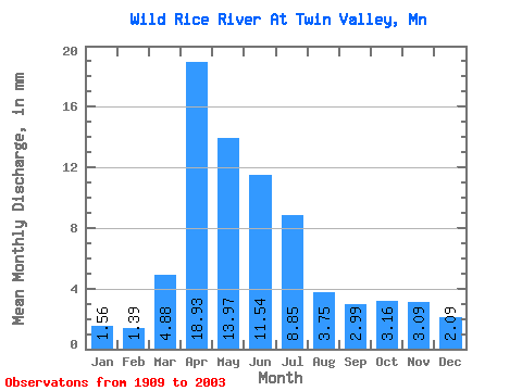
| Statistic | Jan | Feb | Mar | Apr | May | Jun | Jul | Aug | Sep | Oct | Nov | Dec | Annual |
|---|---|---|---|---|---|---|---|---|---|---|---|---|---|
| Mean | 1.56 | 1.40 | 4.88 | 18.93 | 13.97 | 11.54 | 8.85 | 3.75 | 2.99 | 3.16 | 3.09 | 2.09 | 76.16 |
| Standard Deviation | 1.22 | 1.38 | 5.35 | 15.25 | 10.83 | 14.41 | 11.78 | 5.66 | 4.45 | 3.30 | 3.89 | 1.86 | 48.76 |
| Min | 0.12 | 0.11 | 0.40 | 2.24 | 0.97 | 0.80 | 0.25 | 0.10 | 0.06 | 0.19 | 0.28 | 0.19 | 9.88 |
| Max | 6.29 | 9.59 | 25.97 | 74.97 | 70.83 | 104.41 | 60.38 | 32.09 | 25.55 | 19.23 | 28.56 | 10.76 | 238.64 |
| Coefficient of Variation | 0.78 | 0.98 | 1.10 | 0.81 | 0.78 | 1.25 | 1.33 | 1.51 | 1.49 | 1.04 | 1.26 | 0.89 | 0.64 |
 Return to R-Arctic Net Home Page