|
|
|||||||||||||||||
| Point ID: 9725 | Downloads | Plots | Site Data | Code: 05114000 |
|
|
|||||||||||||||||
| Download | |
|---|---|
| Site Descriptor Information | Site Time Series Data |
| Link to all available data | |
| View: | Time Series | All |
| Units: | mm |
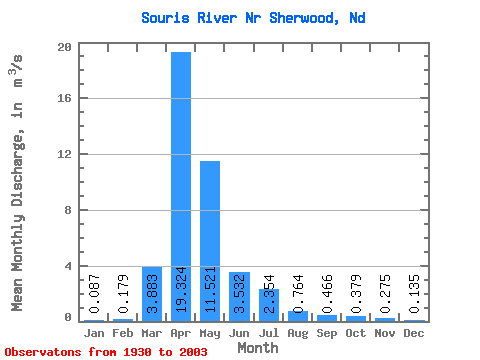
| Statistic | Jan | Feb | Mar | Apr | May | Jun | Jul | Aug | Sep | Oct | Nov | Dec | Annual |
|---|---|---|---|---|---|---|---|---|---|---|---|---|---|
| Mean | 0.09 | 0.18 | 3.88 | 19.32 | 11.52 | 3.53 | 2.35 | 0.76 | 0.47 | 0.38 | 0.28 | 0.14 | 3.63 |
| Standard Deviation | 0.15 | 0.55 | 5.84 | 29.62 | 21.48 | 5.49 | 4.49 | 1.36 | 0.88 | 0.66 | 0.35 | 0.19 | 4.49 |
| Min | 0.00 | 0.00 | 0.00 | 0.05 | 0.07 | 0.01 | 0.00 | 0.00 | 0.00 | 0.00 | 0.00 | 0.00 | 0.01 |
| Max | 1.26 | 4.05 | 32.50 | 190.82 | 113.14 | 27.02 | 29.74 | 9.18 | 4.91 | 3.41 | 1.85 | 1.35 | 24.74 |
| Coefficient of Variation | 1.79 | 3.09 | 1.50 | 1.53 | 1.86 | 1.55 | 1.91 | 1.78 | 1.89 | 1.73 | 1.29 | 1.41 | 1.24 |
 Return to R-Arctic Net Home Page