|
|
|||||||||||||||||
| Point ID: 9725 | Downloads | Plots | Site Data | Code: 05114000 |
|
|
|||||||||||||||||
| Download | |
|---|---|
| Site Descriptor Information | Site Time Series Data |
| Link to all available data | |
| View: | Time Series | All |
| Units: | m3/s |
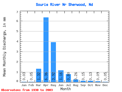
| Statistic | Jan | Feb | Mar | Apr | May | Jun | Jul | Aug | Sep | Oct | Nov | Dec | Annual |
|---|---|---|---|---|---|---|---|---|---|---|---|---|---|
| Mean | 0.01 | 0.02 | 0.45 | 2.16 | 1.33 | 0.40 | 0.27 | 0.09 | 0.05 | 0.04 | 0.03 | 0.02 | 4.95 |
| Standard Deviation | 0.02 | 0.06 | 0.68 | 3.32 | 2.48 | 0.61 | 0.52 | 0.16 | 0.10 | 0.08 | 0.04 | 0.02 | 6.12 |
| Min | 0.00 | 0.00 | 0.00 | 0.01 | 0.01 | 0.00 | 0.00 | 0.00 | 0.00 | 0.00 | 0.00 | 0.00 | 0.02 |
| Max | 0.15 | 0.43 | 3.76 | 21.36 | 13.09 | 3.02 | 3.44 | 1.06 | 0.55 | 0.40 | 0.21 | 0.16 | 33.72 |
| Coefficient of Variation | 1.79 | 3.09 | 1.50 | 1.53 | 1.86 | 1.55 | 1.91 | 1.78 | 1.89 | 1.73 | 1.29 | 1.41 | 1.24 |
 Return to R-Arctic Net Home Page