|
|
|||||||||||||||||
| Point ID: 9719 | Downloads | Plots | Site Data | Code: 05053000 |
|
|
|||||||||||||||||
| Download | |
|---|---|
| Site Descriptor Information | Site Time Series Data |
| Link to all available data | |
| View: | Time Series | All |
| Units: | mm |
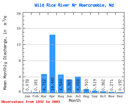
| Statistic | Jan | Feb | Mar | Apr | May | Jun | Jul | Aug | Sep | Oct | Nov | Dec | Annual |
|---|---|---|---|---|---|---|---|---|---|---|---|---|---|
| Mean | 0.08 | 0.18 | 4.71 | 14.44 | 4.54 | 3.37 | 4.06 | 0.91 | 0.52 | 0.36 | 0.27 | 0.19 | 2.82 |
| Standard Deviation | 0.26 | 0.76 | 7.40 | 25.32 | 6.90 | 5.12 | 8.86 | 2.16 | 1.65 | 0.89 | 0.55 | 0.65 | 3.35 |
| Min | 0.00 | 0.00 | 0.00 | 0.08 | 0.00 | 0.00 | 0.00 | 0.00 | 0.00 | 0.00 | 0.00 | 0.00 | 0.01 |
| Max | 2.06 | 5.94 | 33.84 | 156.02 | 35.29 | 26.31 | 50.59 | 13.09 | 12.39 | 4.13 | 3.15 | 5.32 | 16.14 |
| Coefficient of Variation | 3.37 | 4.20 | 1.57 | 1.75 | 1.52 | 1.52 | 2.18 | 2.37 | 3.18 | 2.44 | 2.01 | 3.39 | 1.19 |
 Return to R-Arctic Net Home Page