|
|
|||||||||||||||||
| Point ID: 9719 | Downloads | Plots | Site Data | Code: 05053000 |
|
|
|||||||||||||||||
| Download | |
|---|---|
| Site Descriptor Information | Site Time Series Data |
| Link to all available data | |
| View: | Time Series | All |
| Units: | m3/s |
| Statistic | Jan | Feb | Mar | Apr | May | Jun | Jul | Aug | Sep | Oct | Nov | Dec | Annual |
|---|---|---|---|---|---|---|---|---|---|---|---|---|---|
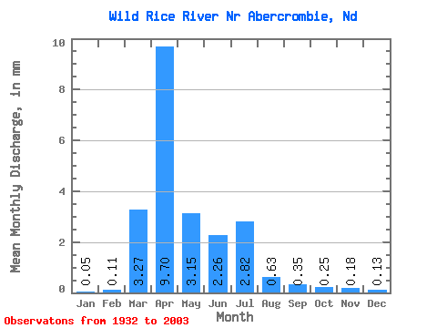
| Mean | 0.04 | 0.08 | 2.34 | 6.95 | 2.26 | 1.62 | 2.02 | 0.45 | 0.25 | 0.18 | 0.13 | 0.10 | 16.54 |
| Standard Deviation | 0.13 | 0.34 | 3.68 | 12.18 | 3.43 | 2.46 | 4.40 | 1.07 | 0.79 | 0.44 | 0.26 | 0.32 | 19.63 |
| Min | 0.00 | 0.00 | 0.00 | 0.04 | 0.00 | 0.00 | 0.00 | 0.00 | 0.00 | 0.00 | 0.00 | 0.00 | 0.08 |
| Max | 1.02 | 2.69 | 16.82 | 75.07 | 17.55 | 12.66 | 25.15 | 6.51 | 5.96 | 2.05 | 1.52 | 2.64 | 94.57 |
| Coefficient of Variation | 3.37 | 4.20 | 1.57 | 1.75 | 1.52 | 1.52 | 2.18 | 2.37 | 3.18 | 2.44 | 2.01 | 3.39 | 1.19 |
 Return to R-Arctic Net Home Page