|
|
|||||||||||||||||
| Point ID: 9717 | Downloads | Plots | Site Data | Code: 05075000 |
|
|
|||||||||||||||||
| Download | |
|---|---|
| Site Descriptor Information | Site Time Series Data |
| Link to all available data | |
| View: | Time Series | All |
| Units: | mm |
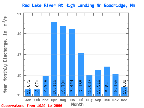
| Statistic | Jan | Feb | Mar | Apr | May | Jun | Jul | Aug | Sep | Oct | Nov | Dec | Annual |
|---|---|---|---|---|---|---|---|---|---|---|---|---|---|
| Mean | 13.68 | 13.67 | 14.95 | 20.12 | 19.73 | 19.42 | 17.16 | 15.09 | 15.52 | 15.84 | 15.16 | 13.89 | 16.10 |
| Standard Deviation | 10.56 | 10.63 | 11.49 | 15.55 | 17.16 | 15.07 | 14.33 | 12.11 | 12.68 | 13.92 | 12.44 | 10.74 | 11.34 |
| Min | 0.00 | 0.00 | 0.00 | 0.70 | 0.16 | 0.03 | 0.17 | 0.00 | 0.00 | 0.06 | 0.04 | 0.00 | 0.20 |
| Max | 40.33 | 38.69 | 41.14 | 56.06 | 90.03 | 61.20 | 70.06 | 41.85 | 49.08 | 55.37 | 48.98 | 43.57 | 43.98 |
| Coefficient of Variation | 0.77 | 0.78 | 0.77 | 0.77 | 0.87 | 0.78 | 0.83 | 0.80 | 0.82 | 0.88 | 0.82 | 0.77 | 0.70 |
 Return to R-Arctic Net Home Page