|
|
|||||||||||||||||
| Point ID: 9717 | Downloads | Plots | Site Data | Code: 05075000 |
|
|
|||||||||||||||||
| Download | |
|---|---|
| Site Descriptor Information | Site Time Series Data |
| Link to all available data | |
| View: | Time Series | All |
| Units: | m3/s |
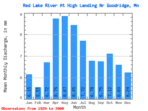
| Statistic | Jan | Feb | Mar | Apr | May | Jun | Jul | Aug | Sep | Oct | Nov | Dec | Annual |
|---|---|---|---|---|---|---|---|---|---|---|---|---|---|
| Mean | 6.15 | 5.60 | 6.72 | 8.75 | 8.87 | 8.45 | 7.72 | 6.78 | 6.75 | 7.12 | 6.60 | 6.24 | 85.30 |
| Standard Deviation | 4.75 | 4.36 | 5.17 | 6.77 | 7.71 | 6.56 | 6.44 | 5.45 | 5.52 | 6.26 | 5.41 | 4.83 | 60.09 |
| Min | 0.00 | 0.00 | 0.00 | 0.30 | 0.07 | 0.01 | 0.08 | 0.00 | 0.00 | 0.03 | 0.02 | 0.00 | 1.08 |
| Max | 18.13 | 15.85 | 18.50 | 24.39 | 40.47 | 26.63 | 31.50 | 18.82 | 21.36 | 24.89 | 21.31 | 19.59 | 232.98 |
| Coefficient of Variation | 0.77 | 0.78 | 0.77 | 0.77 | 0.87 | 0.78 | 0.83 | 0.80 | 0.82 | 0.88 | 0.82 | 0.77 | 0.70 |
 Return to R-Arctic Net Home Page