|
|
|||||||||||||||||
| Point ID: 9715 | Downloads | Plots | Site Data | Code: 05112000 |
|
|
|||||||||||||||||
| Download | |
|---|---|
| Site Descriptor Information | Site Time Series Data |
| Link to all available data | |
| View: | Time Series | All |
| Units: | mm |
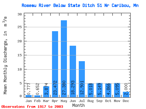
| Statistic | Jan | Feb | Mar | Apr | May | Jun | Jul | Aug | Sep | Oct | Nov | Dec | Annual |
|---|---|---|---|---|---|---|---|---|---|---|---|---|---|
| Mean | 0.78 | 0.65 | 3.87 | 23.47 | 27.38 | 18.29 | 12.90 | 5.02 | 5.15 | 4.87 | 5.09 | 2.00 | 9.82 |
| Standard Deviation | 0.68 | 0.54 | 5.13 | 15.00 | 24.26 | 17.91 | 15.37 | 9.17 | 8.44 | 6.76 | 7.98 | 3.43 | 5.54 |
| Min | 0.00 | 0.00 | 0.04 | 1.08 | 0.76 | 0.19 | 0.02 | 0.06 | 0.01 | 0.00 | 0.01 | 0.01 | 1.24 |
| Max | 3.79 | 2.13 | 22.44 | 61.38 | 85.76 | 73.29 | 87.21 | 44.79 | 41.09 | 36.88 | 57.27 | 23.01 | 20.73 |
| Coefficient of Variation | 0.87 | 0.82 | 1.32 | 0.64 | 0.89 | 0.98 | 1.19 | 1.83 | 1.64 | 1.39 | 1.57 | 1.71 | 0.56 |
 Return to R-Arctic Net Home Page