|
|
|||||||||||||||||
| Point ID: 9715 | Downloads | Plots | Site Data | Code: 05112000 |
|
|
|||||||||||||||||
| Download | |
|---|---|
| Site Descriptor Information | Site Time Series Data |
| Link to all available data | |
| View: | Time Series | All |
| Units: | m3/s |
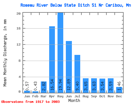
| Statistic | Jan | Feb | Mar | Apr | May | Jun | Jul | Aug | Sep | Oct | Nov | Dec | Annual |
|---|---|---|---|---|---|---|---|---|---|---|---|---|---|
| Mean | 0.57 | 0.43 | 2.82 | 16.54 | 19.94 | 12.89 | 9.39 | 3.65 | 3.63 | 3.54 | 3.59 | 1.46 | 84.30 |
| Standard Deviation | 0.49 | 0.36 | 3.74 | 10.57 | 17.66 | 12.62 | 11.19 | 6.68 | 5.95 | 4.92 | 5.62 | 2.50 | 47.52 |
| Min | 0.00 | 0.00 | 0.03 | 0.76 | 0.56 | 0.13 | 0.01 | 0.04 | 0.01 | 0.00 | 0.01 | 0.01 | 10.63 |
| Max | 2.76 | 1.42 | 16.34 | 43.26 | 62.45 | 51.66 | 63.50 | 32.61 | 28.96 | 26.86 | 40.36 | 16.76 | 177.89 |
| Coefficient of Variation | 0.87 | 0.82 | 1.32 | 0.64 | 0.89 | 0.98 | 1.19 | 1.83 | 1.64 | 1.39 | 1.57 | 1.71 | 0.56 |
 Return to R-Arctic Net Home Page