|
|
|||||||||||||||||
| Point ID: 9714 | Downloads | Plots | Site Data | Code: 05116000 |
|
|
|||||||||||||||||
| Download | |
|---|---|
| Site Descriptor Information | Site Time Series Data |
| Link to all available data | |
| View: | Time Series | All |
| Units: | mm |
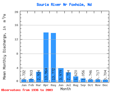
| Statistic | Jan | Feb | Mar | Apr | May | Jun | Jul | Aug | Sep | Oct | Nov | Dec | Annual |
|---|---|---|---|---|---|---|---|---|---|---|---|---|---|
| Mean | 0.73 | 0.90 | 2.93 | 13.96 | 13.77 | 3.98 | 2.79 | 1.62 | 1.06 | 0.75 | 0.72 | 0.70 | 3.71 |
| Standard Deviation | 1.13 | 1.71 | 5.51 | 24.07 | 25.75 | 6.81 | 5.41 | 2.53 | 1.49 | 0.92 | 0.99 | 0.98 | 5.02 |
| Min | 0.00 | 0.00 | 0.00 | 0.00 | 0.00 | 0.00 | 0.00 | 0.00 | 0.00 | 0.00 | 0.00 | 0.00 | 0.01 |
| Max | 4.70 | 9.47 | 29.97 | 154.14 | 120.12 | 32.21 | 35.05 | 12.47 | 9.78 | 4.12 | 3.87 | 4.07 | 26.51 |
| Coefficient of Variation | 1.55 | 1.89 | 1.88 | 1.72 | 1.87 | 1.71 | 1.94 | 1.56 | 1.41 | 1.23 | 1.38 | 1.40 | 1.36 |
 Return to R-Arctic Net Home Page