|
|
|||||||||||||||||
| Point ID: 9712 | Downloads | Plots | Site Data | Code: 05120500 |
|
|
|||||||||||||||||
| Download | |
|---|---|
| Site Descriptor Information | Site Time Series Data |
| Link to all available data | |
| View: | Time Series | All |
| Units: | mm |
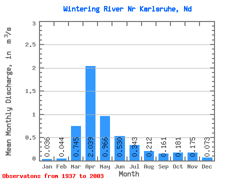
| Statistic | Jan | Feb | Mar | Apr | May | Jun | Jul | Aug | Sep | Oct | Nov | Dec | Annual |
|---|---|---|---|---|---|---|---|---|---|---|---|---|---|
| Mean | 0.04 | 0.04 | 0.74 | 2.04 | 0.97 | 0.53 | 0.34 | 0.21 | 0.16 | 0.18 | 0.17 | 0.07 | 0.46 |
| Standard Deviation | 0.05 | 0.07 | 1.41 | 2.53 | 1.46 | 0.81 | 0.46 | 0.42 | 0.28 | 0.38 | 0.38 | 0.09 | 0.45 |
| Min | 0.00 | 0.00 | 0.00 | 0.08 | 0.05 | 0.01 | 0.01 | 0.00 | 0.00 | 0.00 | 0.01 | 0.00 | 0.03 |
| Max | 0.28 | 0.30 | 9.70 | 13.16 | 8.60 | 5.49 | 2.69 | 2.47 | 1.91 | 3.08 | 2.80 | 0.64 | 2.39 |
| Coefficient of Variation | 1.49 | 1.71 | 1.89 | 1.24 | 1.52 | 1.54 | 1.35 | 1.99 | 1.73 | 2.10 | 2.14 | 1.27 | 0.97 |
 Return to R-Arctic Net Home Page