|
|
|||||||||||||||||
| Point ID: 9712 | Downloads | Plots | Site Data | Code: 05120500 |
|
|
|||||||||||||||||
| Download | |
|---|---|
| Site Descriptor Information | Site Time Series Data |
| Link to all available data | |
| View: | Time Series | All |
| Units: | m3/s |
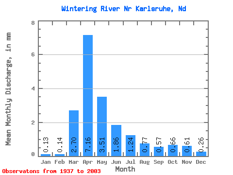
| Statistic | Jan | Feb | Mar | Apr | May | Jun | Jul | Aug | Sep | Oct | Nov | Dec | Annual |
|---|---|---|---|---|---|---|---|---|---|---|---|---|---|
| Mean | 0.05 | 0.06 | 1.09 | 2.89 | 1.42 | 0.75 | 0.50 | 0.31 | 0.23 | 0.27 | 0.25 | 0.11 | 8.02 |
| Standard Deviation | 0.08 | 0.10 | 2.06 | 3.59 | 2.15 | 1.15 | 0.68 | 0.62 | 0.40 | 0.56 | 0.53 | 0.14 | 7.75 |
| Min | 0.00 | 0.00 | 0.00 | 0.11 | 0.07 | 0.02 | 0.01 | 0.00 | 0.00 | 0.00 | 0.02 | 0.00 | 0.51 |
| Max | 0.41 | 0.40 | 14.23 | 18.68 | 12.62 | 7.79 | 3.95 | 3.62 | 2.71 | 4.51 | 3.97 | 0.94 | 41.27 |
| Coefficient of Variation | 1.49 | 1.71 | 1.89 | 1.24 | 1.52 | 1.54 | 1.35 | 1.99 | 1.73 | 2.10 | 2.14 | 1.27 | 0.97 |
 Return to R-Arctic Net Home Page