|
|
|||||||||||||||||
| Point ID: 9710 | Downloads | Plots | Site Data | Code: 05074500 |
|
|
|||||||||||||||||
| Download | |
|---|---|
| Site Descriptor Information | Site Time Series Data |
| Link to all available data | |
| View: | Time Series | All |
| Units: | mm |
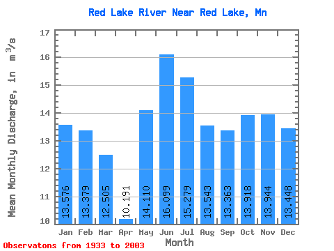
| Statistic | Jan | Feb | Mar | Apr | May | Jun | Jul | Aug | Sep | Oct | Nov | Dec | Annual |
|---|---|---|---|---|---|---|---|---|---|---|---|---|---|
| Mean | 13.58 | 13.38 | 12.51 | 10.19 | 14.11 | 16.10 | 15.28 | 13.54 | 13.36 | 13.92 | 13.94 | 13.45 | 13.79 |
| Standard Deviation | 10.12 | 9.95 | 9.58 | 9.37 | 12.55 | 13.36 | 12.14 | 11.01 | 11.62 | 12.33 | 11.43 | 9.85 | 9.21 |
| Min | 0.01 | 0.01 | 0.02 | 0.11 | 0.02 | 0.06 | 0.13 | 0.08 | 0.05 | 0.14 | 0.10 | 0.03 | 0.15 |
| Max | 40.16 | 38.02 | 39.54 | 38.42 | 45.99 | 57.33 | 52.09 | 41.46 | 48.47 | 58.65 | 49.99 | 42.41 | 38.08 |
| Coefficient of Variation | 0.74 | 0.74 | 0.77 | 0.92 | 0.89 | 0.83 | 0.80 | 0.81 | 0.87 | 0.89 | 0.82 | 0.73 | 0.67 |
 Return to R-Arctic Net Home Page