|
|
|||||||||||||||||
| Point ID: 9710 | Downloads | Plots | Site Data | Code: 05074500 |
|
|
|||||||||||||||||
| Download | |
|---|---|
| Site Descriptor Information | Site Time Series Data |
| Link to all available data | |
| View: | Time Series | All |
| Units: | m3/s |
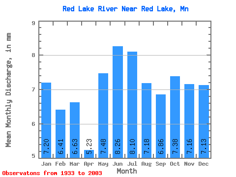
| Statistic | Jan | Feb | Mar | Apr | May | Jun | Jul | Aug | Sep | Oct | Nov | Dec | Annual |
|---|---|---|---|---|---|---|---|---|---|---|---|---|---|
| Mean | 7.20 | 6.46 | 6.63 | 5.23 | 7.48 | 8.26 | 8.10 | 7.18 | 6.86 | 7.38 | 7.16 | 7.13 | 86.18 |
| Standard Deviation | 5.36 | 4.81 | 5.08 | 4.81 | 6.66 | 6.86 | 6.44 | 5.84 | 5.96 | 6.54 | 5.87 | 5.22 | 57.52 |
| Min | 0.01 | 0.01 | 0.01 | 0.06 | 0.01 | 0.03 | 0.07 | 0.04 | 0.02 | 0.08 | 0.05 | 0.01 | 0.96 |
| Max | 21.29 | 18.37 | 20.97 | 19.72 | 24.39 | 29.42 | 27.62 | 21.98 | 24.88 | 31.10 | 25.66 | 22.49 | 237.94 |
| Coefficient of Variation | 0.74 | 0.74 | 0.77 | 0.92 | 0.89 | 0.83 | 0.80 | 0.81 | 0.87 | 0.89 | 0.82 | 0.73 | 0.67 |
 Return to R-Arctic Net Home Page