|
|
|||||||||||||||||
| Point ID: 9703 | Downloads | Plots | Site Data | Code: 05116500 |
|
|
|||||||||||||||||
| Download | |
|---|---|
| Site Descriptor Information | Site Time Series Data |
| Link to all available data | |
| View: | Time Series | All |
| Units: | mm |
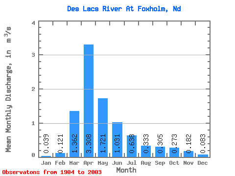
| Statistic | Jan | Feb | Mar | Apr | May | Jun | Jul | Aug | Sep | Oct | Nov | Dec | Annual |
|---|---|---|---|---|---|---|---|---|---|---|---|---|---|
| Mean | 0.04 | 0.12 | 1.36 | 3.31 | 1.72 | 1.03 | 0.64 | 0.33 | 0.30 | 0.27 | 0.18 | 0.08 | 0.80 |
| Standard Deviation | 0.06 | 0.33 | 1.88 | 4.41 | 2.88 | 1.47 | 1.02 | 0.57 | 0.58 | 0.44 | 0.26 | 0.12 | 0.93 |
| Min | 0.00 | 0.00 | 0.00 | 0.05 | 0.01 | 0.00 | 0.00 | 0.00 | 0.00 | 0.00 | 0.00 | 0.00 | 0.01 |
| Max | 0.24 | 2.15 | 10.26 | 20.68 | 11.31 | 6.45 | 6.11 | 3.05 | 2.77 | 2.36 | 1.44 | 0.46 | 3.85 |
| Coefficient of Variation | 1.56 | 2.69 | 1.38 | 1.33 | 1.68 | 1.43 | 1.60 | 1.71 | 1.92 | 1.62 | 1.42 | 1.41 | 1.16 |
 Return to R-Arctic Net Home Page