|
|
|||||||||||||||||
| Point ID: 9703 | Downloads | Plots | Site Data | Code: 05116500 |
|
|
|||||||||||||||||
| Download | |
|---|---|
| Site Descriptor Information | Site Time Series Data |
| Link to all available data | |
| View: | Time Series | All |
| Units: | m3/s |
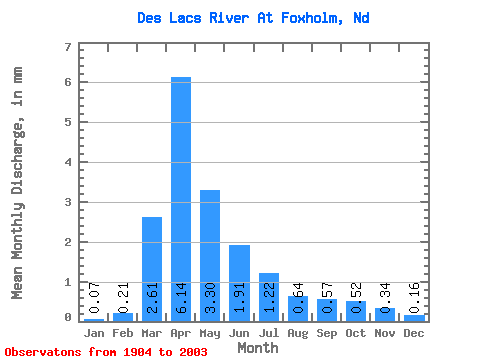
| Statistic | Jan | Feb | Mar | Apr | May | Jun | Jul | Aug | Sep | Oct | Nov | Dec | Annual |
|---|---|---|---|---|---|---|---|---|---|---|---|---|---|
| Mean | 0.04 | 0.12 | 1.50 | 3.53 | 1.90 | 1.10 | 0.70 | 0.37 | 0.33 | 0.30 | 0.19 | 0.09 | 10.38 |
| Standard Deviation | 0.07 | 0.33 | 2.07 | 4.70 | 3.17 | 1.57 | 1.13 | 0.63 | 0.62 | 0.49 | 0.28 | 0.13 | 12.04 |
| Min | 0.00 | 0.00 | 0.00 | 0.05 | 0.01 | 0.00 | 0.00 | 0.00 | 0.00 | 0.00 | 0.00 | 0.00 | 0.17 |
| Max | 0.27 | 2.16 | 11.30 | 22.04 | 12.45 | 6.88 | 6.73 | 3.36 | 2.96 | 2.60 | 1.53 | 0.51 | 49.93 |
| Coefficient of Variation | 1.56 | 2.69 | 1.38 | 1.33 | 1.68 | 1.43 | 1.60 | 1.71 | 1.92 | 1.62 | 1.42 | 1.41 | 1.16 |
 Return to R-Arctic Net Home Page