|
|
|||||||||||||||||
| Point ID: 9698 | Downloads | Plots | Site Data | Code: 05129000 |
|
|
|||||||||||||||||
| Download | |
|---|---|
| Site Descriptor Information | Site Time Series Data |
| Link to all available data | |
| View: | Time Series | All |
| Units: | mm |
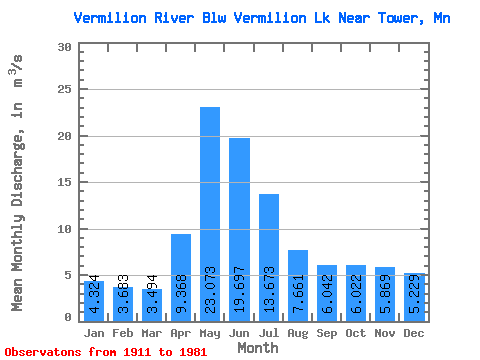
| Statistic | Jan | Feb | Mar | Apr | May | Jun | Jul | Aug | Sep | Oct | Nov | Dec | Annual |
|---|---|---|---|---|---|---|---|---|---|---|---|---|---|
| Mean | 4.32 | 3.68 | 3.49 | 9.37 | 23.07 | 19.70 | 13.67 | 7.66 | 6.04 | 6.02 | 5.87 | 5.23 | 9.01 |
| Standard Deviation | 2.59 | 1.74 | 1.49 | 6.09 | 12.27 | 8.95 | 6.88 | 4.82 | 4.65 | 5.67 | 5.47 | 3.94 | 3.07 |
| Min | 0.01 | 0.01 | 0.01 | 0.11 | 0.44 | 3.00 | 2.81 | 1.32 | 0.03 | 0.02 | 0.01 | 0.01 | 4.17 |
| Max | 11.48 | 8.77 | 8.63 | 31.41 | 56.73 | 42.67 | 44.08 | 28.02 | 22.88 | 26.92 | 22.41 | 16.73 | 15.77 |
| Coefficient of Variation | 0.60 | 0.47 | 0.43 | 0.65 | 0.53 | 0.45 | 0.50 | 0.63 | 0.77 | 0.94 | 0.93 | 0.75 | 0.34 |
 Return to R-Arctic Net Home Page