|
|
|||||||||||||||||
| Point ID: 9698 | Downloads | Plots | Site Data | Code: 05129000 |
|
|
|||||||||||||||||
| Download | |
|---|---|
| Site Descriptor Information | Site Time Series Data |
| Link to all available data | |
| View: | Time Series | All |
| Units: | m3/s |
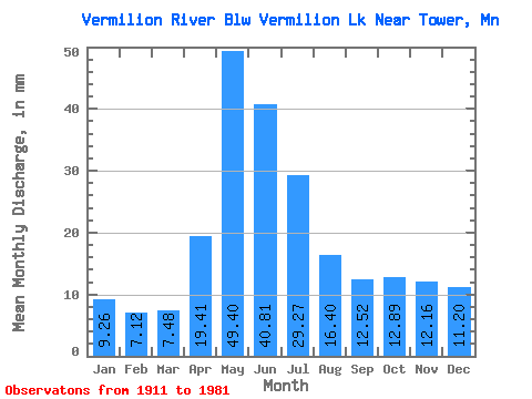
| Statistic | Jan | Feb | Mar | Apr | May | Jun | Jul | Aug | Sep | Oct | Nov | Dec | Annual |
|---|---|---|---|---|---|---|---|---|---|---|---|---|---|
| Mean | 9.26 | 7.18 | 7.48 | 19.41 | 49.39 | 40.81 | 29.27 | 16.40 | 12.52 | 12.89 | 12.16 | 11.19 | 227.31 |
| Standard Deviation | 5.54 | 3.40 | 3.19 | 12.61 | 26.26 | 18.54 | 14.73 | 10.32 | 9.63 | 12.14 | 11.34 | 8.43 | 77.46 |
| Min | 0.02 | 0.02 | 0.03 | 0.23 | 0.95 | 6.22 | 6.02 | 2.83 | 0.05 | 0.04 | 0.03 | 0.02 | 105.22 |
| Max | 24.57 | 17.10 | 18.48 | 65.08 | 121.44 | 88.42 | 94.37 | 59.99 | 47.40 | 57.62 | 46.43 | 35.81 | 397.88 |
| Coefficient of Variation | 0.60 | 0.47 | 0.43 | 0.65 | 0.53 | 0.45 | 0.50 | 0.63 | 0.77 | 0.94 | 0.93 | 0.75 | 0.34 |
 Return to R-Arctic Net Home Page