|
|
|||||||||||||||||
| Point ID: 9693 | Downloads | Plots | Site Data | Code: 05099600 |
|
|
|||||||||||||||||
| Download | |
|---|---|
| Site Descriptor Information | Site Time Series Data |
| Link to all available data | |
| View: | Time Series | All |
| Units: | mm |
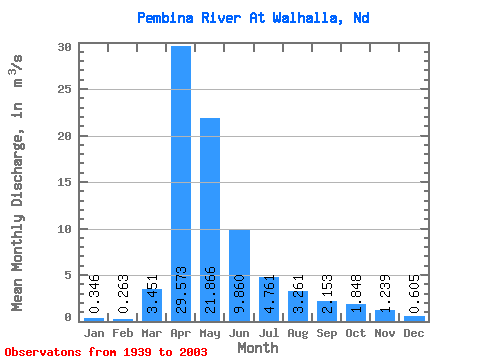
| Statistic | Jan | Feb | Mar | Apr | May | Jun | Jul | Aug | Sep | Oct | Nov | Dec | Annual |
|---|---|---|---|---|---|---|---|---|---|---|---|---|---|
| Mean | 0.35 | 0.26 | 3.45 | 29.57 | 21.87 | 9.86 | 4.76 | 3.26 | 2.15 | 1.85 | 1.24 | 0.60 | 6.43 |
| Standard Deviation | 0.52 | 0.35 | 6.44 | 31.24 | 27.47 | 10.47 | 5.13 | 4.79 | 2.49 | 2.76 | 1.98 | 0.95 | 5.47 |
| Min | 0.00 | 0.00 | 0.00 | 1.41 | 0.53 | 0.08 | 0.02 | 0.00 | 0.00 | 0.00 | 0.00 | 0.00 | 0.28 |
| Max | 3.39 | 1.95 | 34.16 | 140.18 | 132.30 | 54.75 | 23.06 | 27.17 | 12.23 | 16.99 | 12.85 | 6.13 | 26.19 |
| Coefficient of Variation | 1.51 | 1.34 | 1.87 | 1.06 | 1.26 | 1.06 | 1.08 | 1.47 | 1.16 | 1.50 | 1.60 | 1.57 | 0.85 |
 Return to R-Arctic Net Home Page