|
|
|||||||||||||||||
| Point ID: 9693 | Downloads | Plots | Site Data | Code: 05099600 |
|
|
|||||||||||||||||
| Download | |
|---|---|
| Site Descriptor Information | Site Time Series Data |
| Link to all available data | |
| View: | Time Series | All |
| Units: | m3/s |
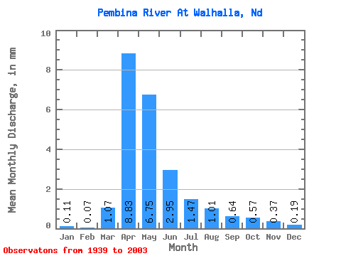
| Statistic | Jan | Feb | Mar | Apr | May | Jun | Jul | Aug | Sep | Oct | Nov | Dec | Annual |
|---|---|---|---|---|---|---|---|---|---|---|---|---|---|
| Mean | 0.11 | 0.07 | 1.06 | 8.84 | 6.75 | 2.94 | 1.47 | 1.01 | 0.64 | 0.57 | 0.37 | 0.19 | 23.37 |
| Standard Deviation | 0.16 | 0.10 | 1.99 | 9.33 | 8.48 | 3.13 | 1.58 | 1.48 | 0.74 | 0.85 | 0.59 | 0.29 | 19.90 |
| Min | 0.00 | 0.00 | 0.00 | 0.42 | 0.17 | 0.02 | 0.01 | 0.00 | 0.00 | 0.00 | 0.00 | 0.00 | 1.02 |
| Max | 1.05 | 0.55 | 10.54 | 41.88 | 40.84 | 16.36 | 7.12 | 8.39 | 3.65 | 5.24 | 3.84 | 1.89 | 95.27 |
| Coefficient of Variation | 1.51 | 1.34 | 1.87 | 1.06 | 1.26 | 1.06 | 1.08 | 1.47 | 1.16 | 1.50 | 1.60 | 1.57 | 0.85 |
 Return to R-Arctic Net Home Page