|
|
|||||||||||||||||
| Point ID: 9692 | Downloads | Plots | Site Data | Code: 05061500 |
|
|
|||||||||||||||||
| Download | |
|---|---|
| Site Descriptor Information | Site Time Series Data |
| Link to all available data | |
| View: | Time Series | All |
| Units: | mm |
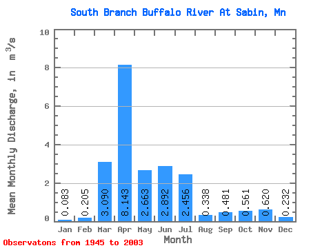
| Statistic | Jan | Feb | Mar | Apr | May | Jun | Jul | Aug | Sep | Oct | Nov | Dec | Annual |
|---|---|---|---|---|---|---|---|---|---|---|---|---|---|
| Mean | 0.08 | 0.20 | 3.09 | 8.14 | 2.66 | 2.89 | 2.46 | 0.34 | 0.48 | 0.56 | 0.62 | 0.23 | 1.86 |
| Standard Deviation | 0.12 | 0.79 | 3.85 | 8.92 | 3.19 | 4.93 | 5.09 | 0.66 | 1.01 | 0.61 | 0.84 | 0.33 | 1.39 |
| Min | 0.00 | 0.00 | 0.00 | 0.79 | 0.23 | 0.04 | 0.00 | 0.00 | 0.00 | 0.00 | 0.06 | 0.00 | 0.36 |
| Max | 0.52 | 5.80 | 16.46 | 47.65 | 16.43 | 30.24 | 31.50 | 4.31 | 5.27 | 3.05 | 5.50 | 1.89 | 5.71 |
| Coefficient of Variation | 1.50 | 3.85 | 1.25 | 1.09 | 1.20 | 1.71 | 2.07 | 1.96 | 2.10 | 1.09 | 1.35 | 1.41 | 0.75 |
 Return to R-Arctic Net Home Page