|
|
|||||||||||||||||
| Point ID: 9692 | Downloads | Plots | Site Data | Code: 05061500 |
|
|
|||||||||||||||||
| Download | |
|---|---|
| Site Descriptor Information | Site Time Series Data |
| Link to all available data | |
| View: | Time Series | All |
| Units: | m3/s |
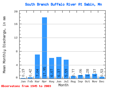
| Statistic | Jan | Feb | Mar | Apr | May | Jun | Jul | Aug | Sep | Oct | Nov | Dec | Annual |
|---|---|---|---|---|---|---|---|---|---|---|---|---|---|
| Mean | 0.19 | 0.42 | 7.04 | 17.95 | 6.07 | 6.37 | 5.59 | 0.77 | 1.06 | 1.28 | 1.37 | 0.53 | 49.92 |
| Standard Deviation | 0.28 | 1.64 | 8.77 | 19.66 | 7.26 | 10.87 | 11.59 | 1.51 | 2.22 | 1.39 | 1.84 | 0.74 | 37.26 |
| Min | 0.00 | 0.00 | 0.00 | 1.74 | 0.53 | 0.08 | 0.00 | 0.00 | 0.00 | 0.00 | 0.13 | 0.00 | 9.73 |
| Max | 1.19 | 12.03 | 37.48 | 105.04 | 37.41 | 66.66 | 71.74 | 9.82 | 11.61 | 6.95 | 12.12 | 4.31 | 153.14 |
| Coefficient of Variation | 1.50 | 3.85 | 1.25 | 1.09 | 1.20 | 1.71 | 2.07 | 1.96 | 2.10 | 1.09 | 1.35 | 1.41 | 0.75 |
 Return to R-Arctic Net Home Page