|
|
|||||||||||||||||
| Point ID: 9682 | Downloads | Plots | Site Data | Code: 05123400 |
|
|
|||||||||||||||||
| Download | |
|---|---|
| Site Descriptor Information | Site Time Series Data |
| Link to all available data | |
| View: | Time Series | All |
| Units: | mm |
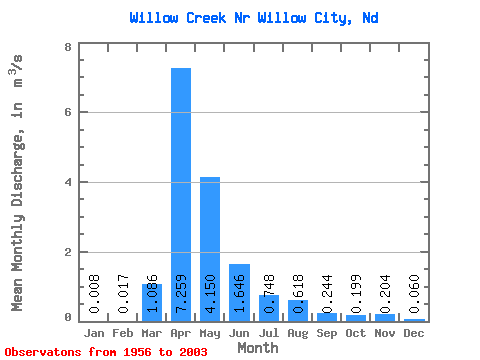
| Statistic | Jan | Feb | Mar | Apr | May | Jun | Jul | Aug | Sep | Oct | Nov | Dec | Annual |
|---|---|---|---|---|---|---|---|---|---|---|---|---|---|
| Mean | 0.01 | 0.02 | 1.09 | 7.26 | 4.15 | 1.65 | 0.75 | 0.62 | 0.24 | 0.20 | 0.20 | 0.06 | 1.38 |
| Standard Deviation | 0.02 | 0.07 | 2.09 | 9.40 | 7.33 | 3.56 | 1.36 | 1.22 | 0.53 | 0.41 | 0.39 | 0.13 | 1.73 |
| Min | 0.00 | 0.00 | 0.00 | 0.00 | 0.00 | 0.00 | 0.00 | 0.00 | 0.00 | 0.00 | 0.00 | 0.00 | 0.00 |
| Max | 0.12 | 0.47 | 9.67 | 35.18 | 40.32 | 21.78 | 7.22 | 5.57 | 2.14 | 2.03 | 1.64 | 0.70 | 9.06 |
| Coefficient of Variation | 2.81 | 4.11 | 1.93 | 1.29 | 1.77 | 2.16 | 1.82 | 1.97 | 2.17 | 2.06 | 1.93 | 2.25 | 1.25 |
 Return to R-Arctic Net Home Page