|
|
|||||||||||||||||
| Point ID: 9682 | Downloads | Plots | Site Data | Code: 05123400 |
|
|
|||||||||||||||||
| Download | |
|---|---|
| Site Descriptor Information | Site Time Series Data |
| Link to all available data | |
| View: | Time Series | All |
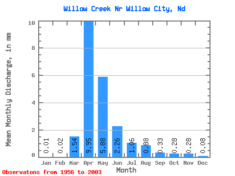
| Units: | m3/s |
| Statistic | Jan | Feb | Mar | Apr | May | Jun | Jul | Aug | Sep | Oct | Nov | Dec | Annual |
|---|---|---|---|---|---|---|---|---|---|---|---|---|---|
| Mean | 0.01 | 0.01 | 0.97 | 6.26 | 3.70 | 1.42 | 0.67 | 0.55 | 0.21 | 0.18 | 0.18 | 0.05 | 14.49 |
| Standard Deviation | 0.02 | 0.06 | 1.87 | 8.11 | 6.54 | 3.07 | 1.21 | 1.09 | 0.46 | 0.37 | 0.34 | 0.12 | 18.15 |
| Min | 0.00 | 0.00 | 0.00 | 0.00 | 0.00 | 0.00 | 0.00 | 0.00 | 0.00 | 0.00 | 0.00 | 0.00 | 0.00 |
| Max | 0.11 | 0.38 | 8.62 | 30.35 | 35.94 | 18.79 | 6.44 | 4.97 | 1.84 | 1.81 | 1.41 | 0.62 | 95.21 |
| Coefficient of Variation | 2.81 | 4.11 | 1.93 | 1.29 | 1.77 | 2.16 | 1.82 | 1.97 | 2.17 | 2.06 | 1.93 | 2.25 | 1.25 |
 Return to R-Arctic Net Home Page