|
|
|||||||||||||||||
| Point ID: 9678 | Downloads | Plots | Site Data | Code: 05089000 |
|
|
|||||||||||||||||
| Download | |
|---|---|
| Site Descriptor Information | Site Time Series Data |
| Link to all available data | |
| View: | Time Series | All |
| Units: | mm |
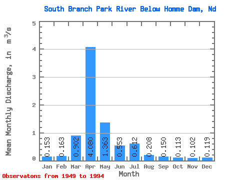
| Statistic | Jan | Feb | Mar | Apr | May | Jun | Jul | Aug | Sep | Oct | Nov | Dec | Annual |
|---|---|---|---|---|---|---|---|---|---|---|---|---|---|
| Mean | 0.15 | 0.16 | 0.90 | 4.08 | 1.36 | 0.55 | 0.61 | 0.21 | 0.15 | 0.11 | 0.10 | 0.12 | 0.71 |
| Standard Deviation | 0.14 | 0.15 | 1.37 | 4.92 | 3.23 | 0.85 | 2.13 | 0.81 | 0.23 | 0.17 | 0.10 | 0.09 | 0.69 |
| Min | 0.00 | 0.00 | 0.00 | 0.02 | 0.02 | 0.02 | 0.00 | 0.00 | 0.00 | 0.00 | 0.00 | 0.00 | 0.01 |
| Max | 0.89 | 0.81 | 6.63 | 21.22 | 19.99 | 5.14 | 14.16 | 5.48 | 1.03 | 0.73 | 0.45 | 0.35 | 3.53 |
| Coefficient of Variation | 0.94 | 0.95 | 1.52 | 1.21 | 2.37 | 1.54 | 3.48 | 3.90 | 1.55 | 1.50 | 0.93 | 0.76 | 0.97 |
 Return to R-Arctic Net Home Page