|
|
|||||||||||||||||
| Point ID: 9678 | Downloads | Plots | Site Data | Code: 05089000 |
|
|
|||||||||||||||||
| Download | |
|---|---|
| Site Descriptor Information | Site Time Series Data |
| Link to all available data | |
| View: | Time Series | All |
| Units: | m3/s |
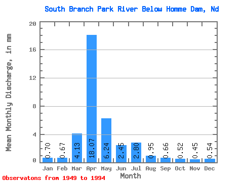
| Statistic | Jan | Feb | Mar | Apr | May | Jun | Jul | Aug | Sep | Oct | Nov | Dec | Annual |
|---|---|---|---|---|---|---|---|---|---|---|---|---|---|
| Mean | 0.70 | 0.68 | 4.13 | 18.07 | 6.24 | 2.45 | 2.80 | 0.95 | 0.66 | 0.52 | 0.45 | 0.55 | 38.27 |
| Standard Deviation | 0.66 | 0.65 | 6.26 | 21.77 | 14.79 | 3.78 | 9.72 | 3.71 | 1.02 | 0.78 | 0.42 | 0.41 | 37.25 |
| Min | 0.00 | 0.00 | 0.01 | 0.08 | 0.09 | 0.10 | 0.01 | 0.00 | 0.00 | 0.00 | 0.00 | 0.00 | 0.80 |
| Max | 4.05 | 3.38 | 30.33 | 93.97 | 91.45 | 22.75 | 64.80 | 25.08 | 4.54 | 3.33 | 2.00 | 1.58 | 190.37 |
| Coefficient of Variation | 0.94 | 0.95 | 1.52 | 1.21 | 2.37 | 1.54 | 3.48 | 3.90 | 1.55 | 1.50 | 0.93 | 0.76 | 0.97 |
 Return to R-Arctic Net Home Page