|
|
|||||||||||||||||
| Point ID: 9676 | Downloads | Plots | Site Data | Code: 05101000 |
|
|
|||||||||||||||||
| Download | |
|---|---|
| Site Descriptor Information | Site Time Series Data |
| Link to all available data | |
| View: | Time Series | All |
| Units: | mm |
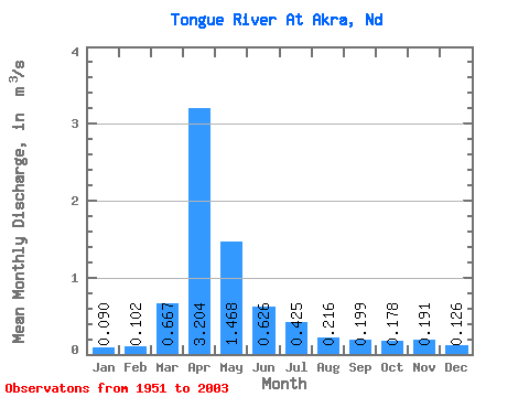
| Statistic | Jan | Feb | Mar | Apr | May | Jun | Jul | Aug | Sep | Oct | Nov | Dec | Annual |
|---|---|---|---|---|---|---|---|---|---|---|---|---|---|
| Mean | 0.09 | 0.10 | 0.67 | 3.20 | 1.47 | 0.63 | 0.42 | 0.22 | 0.20 | 0.18 | 0.19 | 0.13 | 0.61 |
| Standard Deviation | 0.05 | 0.10 | 0.85 | 2.77 | 1.92 | 0.86 | 0.92 | 0.56 | 0.24 | 0.18 | 0.15 | 0.09 | 0.41 |
| Min | 0.01 | 0.01 | 0.01 | 0.01 | 0.05 | 0.01 | 0.00 | 0.01 | 0.00 | 0.01 | 0.02 | 0.00 | 0.09 |
| Max | 0.21 | 0.53 | 3.82 | 9.00 | 8.30 | 5.56 | 6.13 | 4.07 | 1.21 | 0.85 | 0.64 | 0.36 | 1.43 |
| Coefficient of Variation | 0.57 | 0.98 | 1.28 | 0.86 | 1.31 | 1.38 | 2.18 | 2.61 | 1.20 | 1.02 | 0.76 | 0.74 | 0.67 |
 Return to R-Arctic Net Home Page