|
|
|||||||||||||||||
| Point ID: 9676 | Downloads | Plots | Site Data | Code: 05101000 |
|
|
|||||||||||||||||
| Download | |
|---|---|
| Site Descriptor Information | Site Time Series Data |
| Link to all available data | |
| View: | Time Series | All |
| Units: | m3/s |
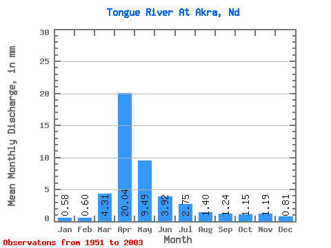
| Statistic | Jan | Feb | Mar | Apr | May | Jun | Jul | Aug | Sep | Oct | Nov | Dec | Annual |
|---|---|---|---|---|---|---|---|---|---|---|---|---|---|
| Mean | 0.58 | 0.60 | 4.31 | 20.04 | 9.49 | 3.91 | 2.74 | 1.40 | 1.25 | 1.15 | 1.20 | 0.82 | 46.45 |
| Standard Deviation | 0.33 | 0.59 | 5.51 | 17.30 | 12.40 | 5.41 | 5.97 | 3.63 | 1.49 | 1.17 | 0.91 | 0.60 | 31.18 |
| Min | 0.09 | 0.04 | 0.04 | 0.07 | 0.30 | 0.08 | 0.02 | 0.04 | 0.02 | 0.09 | 0.10 | 0.01 | 6.46 |
| Max | 1.33 | 3.12 | 24.69 | 56.28 | 53.67 | 34.79 | 39.59 | 26.30 | 7.59 | 5.50 | 4.02 | 2.36 | 108.76 |
| Coefficient of Variation | 0.57 | 0.98 | 1.28 | 0.86 | 1.31 | 1.38 | 2.18 | 2.61 | 1.20 | 1.02 | 0.76 | 0.74 | 0.67 |
 Return to R-Arctic Net Home Page