|
|
|||||||||||||||||
| Point ID: 9670 | Downloads | Plots | Site Data | Code: 05064900 |
|
|
|||||||||||||||||
| Download | |
|---|---|
| Site Descriptor Information | Site Time Series Data |
| Link to all available data | |
| View: | Time Series | All |
| Units: | mm |
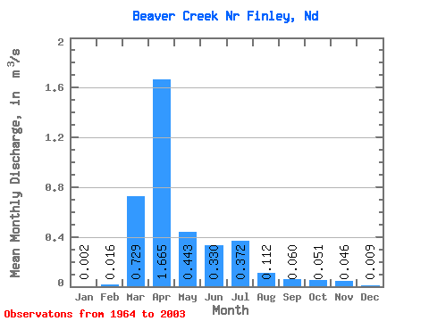
| Statistic | Jan | Feb | Mar | Apr | May | Jun | Jul | Aug | Sep | Oct | Nov | Dec | Annual |
|---|---|---|---|---|---|---|---|---|---|---|---|---|---|
| Mean | 0.00 | 0.02 | 0.73 | 1.67 | 0.44 | 0.33 | 0.37 | 0.11 | 0.06 | 0.05 | 0.05 | 0.01 | 0.33 |
| Standard Deviation | 0.01 | 0.04 | 0.84 | 1.93 | 0.64 | 0.75 | 0.74 | 0.25 | 0.14 | 0.14 | 0.14 | 0.02 | 0.27 |
| Min | 0.00 | 0.00 | 0.00 | 0.01 | 0.00 | 0.00 | 0.00 | 0.00 | 0.00 | 0.00 | 0.00 | 0.00 | 0.01 |
| Max | 0.03 | 0.22 | 4.28 | 7.12 | 2.52 | 4.23 | 3.29 | 1.23 | 0.60 | 0.86 | 0.72 | 0.12 | 0.93 |
| Coefficient of Variation | 2.80 | 2.80 | 1.15 | 1.16 | 1.43 | 2.26 | 2.00 | 2.25 | 2.29 | 2.81 | 2.99 | 2.63 | 0.82 |
 Return to R-Arctic Net Home Page