|
|
|||||||||||||||||
| Point ID: 9670 | Downloads | Plots | Site Data | Code: 05064900 |
|
|
|||||||||||||||||
| Download | |
|---|---|
| Site Descriptor Information | Site Time Series Data |
| Link to all available data | |
| View: | Time Series | All |
| Units: | m3/s |
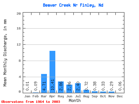
| Statistic | Jan | Feb | Mar | Apr | May | Jun | Jul | Aug | Sep | Oct | Nov | Dec | Annual |
|---|---|---|---|---|---|---|---|---|---|---|---|---|---|
| Mean | 0.02 | 0.09 | 4.71 | 10.41 | 2.86 | 2.07 | 2.40 | 0.73 | 0.38 | 0.33 | 0.29 | 0.06 | 24.71 |
| Standard Deviation | 0.04 | 0.26 | 5.42 | 12.09 | 4.10 | 4.68 | 4.80 | 1.63 | 0.86 | 0.92 | 0.87 | 0.15 | 20.22 |
| Min | 0.00 | 0.00 | 0.00 | 0.03 | 0.01 | 0.00 | 0.00 | 0.00 | 0.00 | 0.00 | 0.00 | 0.00 | 0.39 |
| Max | 0.19 | 1.32 | 27.66 | 44.56 | 16.31 | 26.48 | 21.24 | 7.94 | 3.76 | 5.54 | 4.50 | 0.79 | 70.63 |
| Coefficient of Variation | 2.80 | 2.80 | 1.15 | 1.16 | 1.43 | 2.26 | 2.00 | 2.25 | 2.29 | 2.81 | 2.99 | 2.63 | 0.82 |
 Return to R-Arctic Net Home Page