|
|
|||||||||||||||||
| Point ID: 9665 | Downloads | Plots | Site Data | Code: 05123510 |
|
|
|||||||||||||||||
| Download | |
|---|---|
| Site Descriptor Information | Site Time Series Data |
| Link to all available data | |
| View: | Time Series | All |
| Units: | mm |
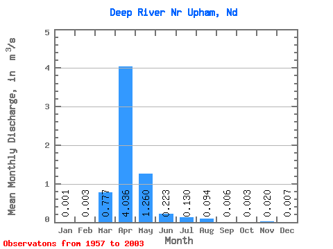
| Statistic | Jan | Feb | Mar | Apr | May | Jun | Jul | Aug | Sep | Oct | Nov | Dec | Annual |
|---|---|---|---|---|---|---|---|---|---|---|---|---|---|
| Mean | 0.00 | 0.00 | 0.78 | 4.04 | 1.26 | 0.22 | 0.13 | 0.09 | 0.01 | 0.00 | 0.02 | 0.01 | 0.61 |
| Standard Deviation | 0.01 | 0.01 | 1.75 | 7.94 | 2.86 | 0.57 | 0.29 | 0.37 | 0.03 | 0.01 | 0.10 | 0.03 | 1.05 |
| Min | 0.00 | 0.00 | 0.00 | 0.00 | 0.00 | 0.00 | 0.00 | 0.00 | 0.00 | 0.00 | 0.00 | 0.00 | 0.00 |
| Max | 0.02 | 0.07 | 7.83 | 36.81 | 13.27 | 3.43 | 1.63 | 2.31 | 0.17 | 0.06 | 0.46 | 0.14 | 3.96 |
| Coefficient of Variation | 4.80 | 4.21 | 2.25 | 1.97 | 2.27 | 2.56 | 2.27 | 3.90 | 4.43 | 3.59 | 4.62 | 4.34 | 1.73 |
 Return to R-Arctic Net Home Page