|
|
|||||||||||||||||
| Point ID: 9665 | Downloads | Plots | Site Data | Code: 05123510 |
|
|
|||||||||||||||||
| Download | |
|---|---|
| Site Descriptor Information | Site Time Series Data |
| Link to all available data | |
| View: | Time Series | All |
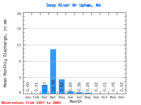
| Units: | m3/s |
| Statistic | Jan | Feb | Mar | Apr | May | Jun | Jul | Aug | Sep | Oct | Nov | Dec | Annual |
|---|---|---|---|---|---|---|---|---|---|---|---|---|---|
| Mean | 0.00 | 0.00 | 0.82 | 4.14 | 1.34 | 0.23 | 0.14 | 0.10 | 0.01 | 0.00 | 0.02 | 0.01 | 7.60 |
| Standard Deviation | 0.01 | 0.01 | 1.85 | 8.15 | 3.04 | 0.59 | 0.31 | 0.39 | 0.03 | 0.01 | 0.10 | 0.03 | 13.16 |
| Min | 0.00 | 0.00 | 0.00 | 0.00 | 0.00 | 0.00 | 0.00 | 0.00 | 0.00 | 0.00 | 0.00 | 0.00 | 0.00 |
| Max | 0.02 | 0.07 | 8.30 | 37.79 | 14.08 | 3.52 | 1.73 | 2.45 | 0.18 | 0.06 | 0.47 | 0.15 | 49.44 |
| Coefficient of Variation | 4.80 | 4.21 | 2.25 | 1.97 | 2.27 | 2.56 | 2.27 | 3.90 | 4.43 | 3.59 | 4.62 | 4.34 | 1.73 |
 Return to R-Arctic Net Home Page