|
|
|||||||||||||||||
| Point ID: 9663 | Downloads | Plots | Site Data | Code: 05139500 |
|
|
|||||||||||||||||
| Download | |
|---|---|
| Site Descriptor Information | Site Time Series Data |
| Link to all available data | |
| View: | Time Series | All |
| Units: | mm |
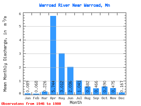
| Statistic | Jan | Feb | Mar | Apr | May | Jun | Jul | Aug | Sep | Oct | Nov | Dec | Annual |
|---|---|---|---|---|---|---|---|---|---|---|---|---|---|
| Mean | 0.09 | 0.07 | 0.23 | 5.74 | 3.01 | 2.04 | 1.04 | 0.58 | 0.47 | 0.59 | 0.47 | 0.17 | 1.26 |
| Standard Deviation | 0.08 | 0.04 | 0.26 | 4.11 | 3.03 | 2.50 | 1.57 | 1.25 | 0.83 | 0.90 | 0.64 | 0.18 | 0.71 |
| Min | 0.00 | 0.00 | 0.01 | 0.40 | 0.20 | 0.03 | 0.00 | 0.00 | 0.00 | 0.02 | 0.00 | 0.00 | 0.21 |
| Max | 0.38 | 0.17 | 0.94 | 15.96 | 14.00 | 9.21 | 5.74 | 5.33 | 3.98 | 4.21 | 3.11 | 0.84 | 2.71 |
| Coefficient of Variation | 0.88 | 0.60 | 1.15 | 0.71 | 1.01 | 1.23 | 1.50 | 2.15 | 1.79 | 1.52 | 1.35 | 1.08 | 0.56 |
 Return to R-Arctic Net Home Page