|
|
|||||||||||||||||
| Point ID: 9663 | Downloads | Plots | Site Data | Code: 05139500 |
|
|
|||||||||||||||||
| Download | |
|---|---|
| Site Descriptor Information | Site Time Series Data |
| Link to all available data | |
| View: | Time Series | All |
| Units: | m3/s |
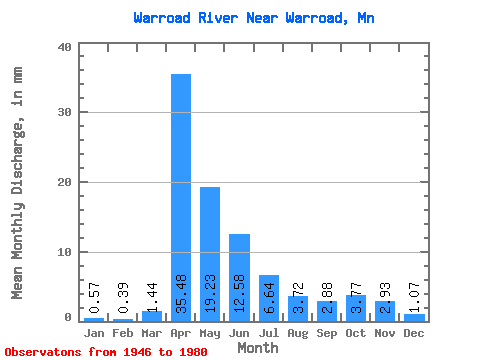
| Statistic | Jan | Feb | Mar | Apr | May | Jun | Jul | Aug | Sep | Oct | Nov | Dec | Annual |
|---|---|---|---|---|---|---|---|---|---|---|---|---|---|
| Mean | 0.57 | 0.40 | 1.44 | 35.48 | 19.22 | 12.57 | 6.64 | 3.71 | 2.88 | 3.77 | 2.93 | 1.06 | 94.58 |
| Standard Deviation | 0.50 | 0.24 | 1.66 | 25.38 | 19.35 | 15.47 | 10.00 | 7.99 | 5.15 | 5.74 | 3.95 | 1.15 | 53.19 |
| Min | 0.00 | 0.00 | 0.09 | 2.44 | 1.26 | 0.17 | 0.00 | 0.00 | 0.01 | 0.10 | 0.02 | 0.00 | 16.04 |
| Max | 2.40 | 0.97 | 6.01 | 98.59 | 89.36 | 56.92 | 36.63 | 33.99 | 24.61 | 26.86 | 19.22 | 5.39 | 204.08 |
| Coefficient of Variation | 0.88 | 0.60 | 1.15 | 0.71 | 1.01 | 1.23 | 1.50 | 2.15 | 1.79 | 1.52 | 1.35 | 1.08 | 0.56 |
 Return to R-Arctic Net Home Page