|
|
|||||||||||||||||
| Point ID: 9660 | Downloads | Plots | Site Data | Code: 05131000 |
|
|
|||||||||||||||||
| Download | |
|---|---|
| Site Descriptor Information | Site Time Series Data |
| Link to all available data | |
| View: | Time Series | All |
| Units: | mm |
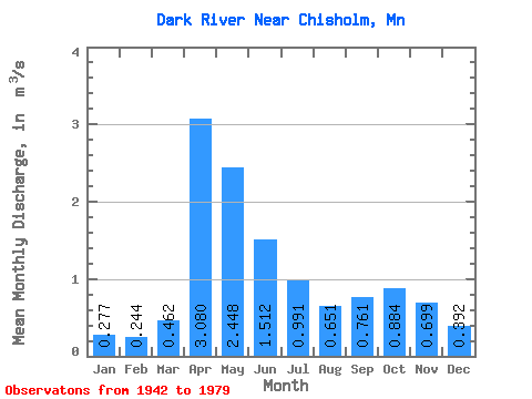
| Statistic | Jan | Feb | Mar | Apr | May | Jun | Jul | Aug | Sep | Oct | Nov | Dec | Annual |
|---|---|---|---|---|---|---|---|---|---|---|---|---|---|
| Mean | 0.28 | 0.24 | 0.46 | 3.08 | 2.45 | 1.51 | 0.99 | 0.65 | 0.76 | 0.88 | 0.70 | 0.39 | 1.04 |
| Standard Deviation | 0.11 | 0.10 | 0.47 | 1.56 | 1.98 | 0.83 | 0.67 | 0.43 | 0.73 | 0.73 | 0.45 | 0.18 | 0.27 |
| Min | 0.14 | 0.10 | 0.14 | 0.35 | 0.20 | 0.41 | 0.16 | 0.11 | 0.07 | 0.10 | 0.18 | 0.18 | 0.47 |
| Max | 0.58 | 0.50 | 2.50 | 7.45 | 11.91 | 4.02 | 3.30 | 1.98 | 3.50 | 2.91 | 2.31 | 0.87 | 1.63 |
| Coefficient of Variation | 0.39 | 0.39 | 1.02 | 0.51 | 0.81 | 0.55 | 0.67 | 0.66 | 0.96 | 0.83 | 0.64 | 0.45 | 0.26 |
 Return to R-Arctic Net Home Page