|
|
|||||||||||||||||
| Point ID: 9660 | Downloads | Plots | Site Data | Code: 05131000 |
|
|
|||||||||||||||||
| Download | |
|---|---|
| Site Descriptor Information | Site Time Series Data |
| Link to all available data | |
| View: | Time Series | All |
| Units: | m3/s |
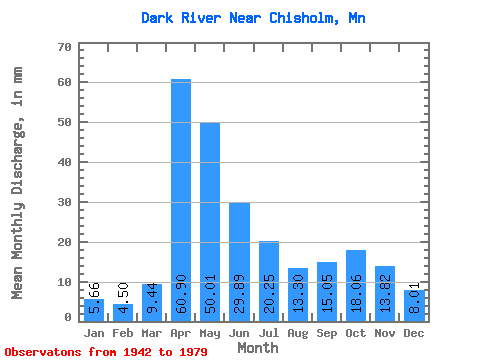
| Statistic | Jan | Feb | Mar | Apr | May | Jun | Jul | Aug | Sep | Oct | Nov | Dec | Annual |
|---|---|---|---|---|---|---|---|---|---|---|---|---|---|
| Mean | 5.66 | 4.55 | 9.43 | 60.90 | 50.01 | 29.89 | 20.24 | 13.30 | 15.05 | 18.07 | 13.82 | 8.01 | 250.83 |
| Standard Deviation | 2.19 | 1.79 | 9.61 | 30.95 | 40.44 | 16.40 | 13.64 | 8.77 | 14.44 | 14.96 | 8.87 | 3.59 | 63.96 |
| Min | 2.94 | 1.80 | 2.96 | 6.97 | 4.04 | 8.14 | 3.33 | 2.32 | 1.36 | 2.08 | 3.47 | 3.79 | 114.27 |
| Max | 11.91 | 9.26 | 51.16 | 147.19 | 243.32 | 79.54 | 67.33 | 40.53 | 69.19 | 59.52 | 45.67 | 17.82 | 392.75 |
| Coefficient of Variation | 0.39 | 0.39 | 1.02 | 0.51 | 0.81 | 0.55 | 0.67 | 0.66 | 0.96 | 0.83 | 0.64 | 0.45 | 0.26 |
 Return to R-Arctic Net Home Page