|
|
|||||||||||||||||
| Point ID: 9653 | Downloads | Plots | Site Data | Code: 05134200 |
|
|
|||||||||||||||||
| Download | |
|---|---|
| Site Descriptor Information | Site Time Series Data |
| Link to all available data | |
| View: | Time Series | All |
| Units: | mm |
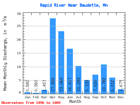
| Statistic | Jan | Feb | Mar | Apr | May | Jun | Jul | Aug | Sep | Oct | Nov | Dec | Annual |
|---|---|---|---|---|---|---|---|---|---|---|---|---|---|
| Mean | 0.58 | 0.36 | 1.46 | 27.83 | 23.06 | 16.62 | 10.28 | 5.13 | 7.02 | 10.78 | 6.01 | 1.68 | 9.00 |
| Standard Deviation | 0.68 | 0.30 | 1.78 | 21.46 | 17.94 | 13.83 | 9.48 | 8.27 | 8.53 | 12.18 | 5.64 | 1.85 | 4.15 |
| Min | 0.00 | 0.00 | 0.05 | 2.33 | 1.59 | 0.42 | 0.09 | 0.03 | 0.04 | 0.04 | 0.03 | 0.00 | 2.82 |
| Max | 3.52 | 1.31 | 5.71 | 93.19 | 58.15 | 46.60 | 41.58 | 37.80 | 26.91 | 48.85 | 24.09 | 7.78 | 17.77 |
| Coefficient of Variation | 1.16 | 0.84 | 1.23 | 0.77 | 0.78 | 0.83 | 0.92 | 1.61 | 1.22 | 1.13 | 0.94 | 1.10 | 0.46 |
 Return to R-Arctic Net Home Page