|
|
|||||||||||||||||
| Point ID: 9653 | Downloads | Plots | Site Data | Code: 05134200 |
|
|
|||||||||||||||||
| Download | |
|---|---|
| Site Descriptor Information | Site Time Series Data |
| Link to all available data | |
| View: | Time Series | All |
| Units: | m3/s |
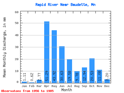
| Statistic | Jan | Feb | Mar | Apr | May | Jun | Jul | Aug | Sep | Oct | Nov | Dec | Annual |
|---|---|---|---|---|---|---|---|---|---|---|---|---|---|
| Mean | 1.11 | 0.62 | 2.77 | 51.29 | 43.91 | 30.62 | 19.58 | 9.77 | 12.94 | 20.53 | 11.08 | 3.20 | 201.92 |
| Standard Deviation | 1.28 | 0.52 | 3.40 | 39.55 | 34.15 | 25.50 | 18.06 | 15.75 | 15.72 | 23.19 | 10.40 | 3.53 | 93.19 |
| Min | 0.00 | 0.00 | 0.09 | 4.30 | 3.03 | 0.77 | 0.17 | 0.06 | 0.07 | 0.07 | 0.05 | 0.01 | 63.35 |
| Max | 6.70 | 2.27 | 10.87 | 171.75 | 110.72 | 85.88 | 79.17 | 71.97 | 49.59 | 93.02 | 44.41 | 14.82 | 398.84 |
| Coefficient of Variation | 1.16 | 0.84 | 1.23 | 0.77 | 0.78 | 0.83 | 0.92 | 1.61 | 1.22 | 1.13 | 0.94 | 1.10 | 0.46 |
 Return to R-Arctic Net Home Page