|
|
|||||||||||||||||
| Point ID: 9646 | Downloads | Plots | Site Data | Code: 05083000 |
|
|
|||||||||||||||||
| Download | |
|---|---|
| Site Descriptor Information | Site Time Series Data |
| Link to all available data | |
| View: | Time Series | All |
| Units: | mm |
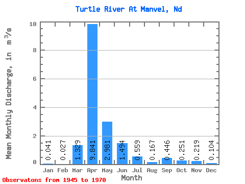
| Statistic | Jan | Feb | Mar | Apr | May | Jun | Jul | Aug | Sep | Oct | Nov | Dec | Annual |
|---|---|---|---|---|---|---|---|---|---|---|---|---|---|
| Mean | 0.04 | 0.03 | 1.33 | 9.84 | 2.98 | 1.49 | 0.56 | 0.17 | 0.45 | 0.25 | 0.22 | 0.10 | 1.43 |
| Standard Deviation | 0.05 | 0.04 | 2.76 | 12.38 | 8.11 | 1.69 | 0.47 | 0.14 | 1.21 | 0.32 | 0.15 | 0.08 | 1.70 |
| Min | 0.00 | 0.00 | 0.00 | 0.66 | 0.22 | 0.10 | 0.03 | 0.01 | 0.01 | 0.02 | 0.02 | 0.00 | 0.22 |
| Max | 0.14 | 0.14 | 13.57 | 56.27 | 41.22 | 7.62 | 1.64 | 0.63 | 6.10 | 1.39 | 0.70 | 0.29 | 8.49 |
| Coefficient of Variation | 1.12 | 1.34 | 2.08 | 1.26 | 2.72 | 1.13 | 0.83 | 0.86 | 2.72 | 1.29 | 0.67 | 0.75 | 1.19 |
 Return to R-Arctic Net Home Page