|
|
|||||||||||||||||
| Point ID: 9646 | Downloads | Plots | Site Data | Code: 05083000 |
|
|
|||||||||||||||||
| Download | |
|---|---|
| Site Descriptor Information | Site Time Series Data |
| Link to all available data | |
| View: | Time Series | All |
| Units: | m3/s |
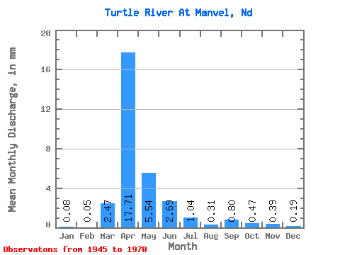
| Statistic | Jan | Feb | Mar | Apr | May | Jun | Jul | Aug | Sep | Oct | Nov | Dec | Annual |
|---|---|---|---|---|---|---|---|---|---|---|---|---|---|
| Mean | 0.07 | 0.04 | 2.24 | 16.07 | 5.03 | 2.44 | 0.94 | 0.28 | 0.73 | 0.42 | 0.36 | 0.17 | 28.39 |
| Standard Deviation | 0.08 | 0.06 | 4.66 | 20.21 | 13.67 | 2.76 | 0.79 | 0.24 | 1.98 | 0.54 | 0.24 | 0.13 | 33.75 |
| Min | 0.00 | 0.00 | 0.00 | 1.07 | 0.38 | 0.16 | 0.05 | 0.01 | 0.01 | 0.03 | 0.03 | 0.01 | 4.44 |
| Max | 0.24 | 0.21 | 22.89 | 91.87 | 69.53 | 12.44 | 2.77 | 1.06 | 9.95 | 2.34 | 1.15 | 0.49 | 168.77 |
| Coefficient of Variation | 1.12 | 1.34 | 2.08 | 1.26 | 2.72 | 1.13 | 0.83 | 0.86 | 2.72 | 1.29 | 0.67 | 0.75 | 1.19 |
 Return to R-Arctic Net Home Page