|
|
|||||||||||||||||
| Point ID: 9644 | Downloads | Plots | Site Data | Code: 05096000 |
|
|
|||||||||||||||||
| Download | |
|---|---|
| Site Descriptor Information | Site Time Series Data |
| Link to all available data | |
| View: | Time Series | All |
| Units: | mm |
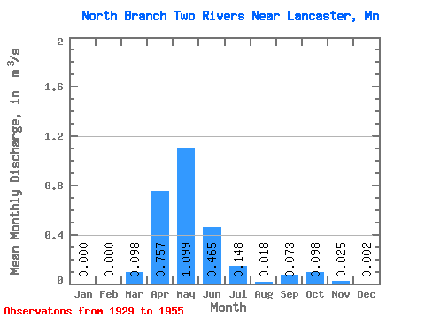
| Statistic | Jan | Feb | Mar | Apr | May | Jun | Jul | Aug | Sep | Oct | Nov | Dec | Annual |
|---|---|---|---|---|---|---|---|---|---|---|---|---|---|
| Mean | 0.00 | 0.00 | 0.10 | 0.76 | 1.10 | 0.47 | 0.15 | 0.02 | 0.07 | 0.10 | 0.03 | 0.00 | 0.24 |
| Standard Deviation | 0.00 | 0.00 | 0.28 | 0.94 | 3.56 | 1.33 | 0.49 | 0.04 | 0.27 | 0.34 | 0.06 | 0.00 | 0.54 |
| Min | 0.00 | 0.00 | 0.00 | 0.00 | 0.00 | 0.00 | 0.00 | 0.00 | 0.00 | 0.00 | 0.00 | 0.00 | 0.00 |
| Max | 0.01 | 0.00 | 1.09 | 3.06 | 17.98 | 6.65 | 2.45 | 0.16 | 1.33 | 1.63 | 0.24 | 0.01 | 2.51 |
| Coefficient of Variation | 3.92 | 4.80 | 2.83 | 1.24 | 3.24 | 2.86 | 3.34 | 2.37 | 3.65 | 3.51 | 2.35 | 1.92 | 2.19 |
 Return to R-Arctic Net Home Page