|
|
|||||||||||||||||
| Point ID: 9644 | Downloads | Plots | Site Data | Code: 05096000 |
|
|
|||||||||||||||||
| Download | |
|---|---|
| Site Descriptor Information | Site Time Series Data |
| Link to all available data | |
| View: | Time Series | All |
| Units: | m3/s |
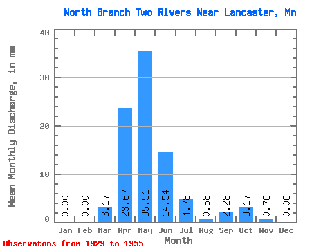
| Statistic | Jan | Feb | Mar | Apr | May | Jun | Jul | Aug | Sep | Oct | Nov | Dec | Annual |
|---|---|---|---|---|---|---|---|---|---|---|---|---|---|
| Mean | 0.01 | 0.00 | 3.18 | 23.67 | 35.49 | 14.54 | 4.79 | 0.57 | 2.27 | 3.16 | 0.80 | 0.06 | 93.34 |
| Standard Deviation | 0.04 | 0.01 | 8.97 | 29.41 | 114.96 | 41.56 | 16.00 | 1.36 | 8.30 | 11.11 | 1.87 | 0.11 | 204.54 |
| Min | 0.00 | 0.00 | 0.00 | 0.09 | 0.01 | 0.00 | 0.00 | 0.00 | 0.00 | 0.00 | 0.00 | 0.00 | 1.05 |
| Max | 0.20 | 0.04 | 35.31 | 95.53 | 580.77 | 208.03 | 79.21 | 5.27 | 41.67 | 52.76 | 7.62 | 0.36 | 954.49 |
| Coefficient of Variation | 3.92 | 4.80 | 2.83 | 1.24 | 3.24 | 2.86 | 3.34 | 2.37 | 3.65 | 3.51 | 2.35 | 1.92 | 2.19 |
 Return to R-Arctic Net Home Page