|
|
|||||||||||||||||
| Point ID: 9643 | Downloads | Plots | Site Data | Code: 05051700 |
|
|
|||||||||||||||||
| Download | |
|---|---|
| Site Descriptor Information | Site Time Series Data |
| Link to all available data | |
| View: | Time Series | All |
| Units: | mm |
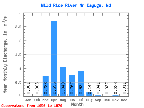
| Statistic | Jan | Feb | Mar | Apr | May | Jun | Jul | Aug | Sep | Oct | Nov | Dec | Annual |
|---|---|---|---|---|---|---|---|---|---|---|---|---|---|
| Mean | 0.00 | 0.01 | 0.73 | 2.70 | 1.05 | 0.77 | 0.92 | 0.14 | 0.04 | 0.03 | 0.03 | 0.01 | 0.52 |
| Standard Deviation | 0.00 | 0.02 | 1.75 | 4.42 | 1.30 | 1.16 | 2.13 | 0.35 | 0.15 | 0.08 | 0.11 | 0.03 | 0.66 |
| Min | 0.00 | 0.00 | 0.00 | 0.00 | 0.00 | 0.00 | 0.00 | 0.00 | 0.00 | 0.00 | 0.00 | 0.00 | 0.00 |
| Max | 0.02 | 0.09 | 7.74 | 20.25 | 4.33 | 4.57 | 9.95 | 1.66 | 0.75 | 0.32 | 0.46 | 0.15 | 2.31 |
| Coefficient of Variation | 4.41 | 3.63 | 2.40 | 1.64 | 1.24 | 1.52 | 2.31 | 2.42 | 3.68 | 3.04 | 3.26 | 3.19 | 1.27 |
 Return to R-Arctic Net Home Page