|
|
|||||||||||||||||
| Point ID: 9643 | Downloads | Plots | Site Data | Code: 05051700 |
|
|
|||||||||||||||||
| Download | |
|---|---|
| Site Descriptor Information | Site Time Series Data |
| Link to all available data | |
| View: | Time Series | All |
| Units: | m3/s |
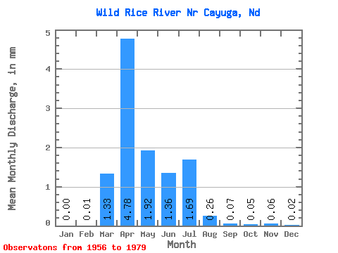
| Statistic | Jan | Feb | Mar | Apr | May | Jun | Jul | Aug | Sep | Oct | Nov | Dec | Annual |
|---|---|---|---|---|---|---|---|---|---|---|---|---|---|
| Mean | 0.00 | 0.01 | 0.79 | 2.83 | 1.14 | 0.80 | 1.00 | 0.16 | 0.04 | 0.03 | 0.04 | 0.01 | 6.67 |
| Standard Deviation | 0.01 | 0.02 | 1.89 | 4.63 | 1.41 | 1.22 | 2.31 | 0.38 | 0.16 | 0.09 | 0.11 | 0.04 | 8.47 |
| Min | 0.00 | 0.00 | 0.00 | 0.00 | 0.00 | 0.00 | 0.00 | 0.00 | 0.00 | 0.00 | 0.00 | 0.00 | 0.00 |
| Max | 0.02 | 0.09 | 8.38 | 21.22 | 4.69 | 4.79 | 10.77 | 1.80 | 0.79 | 0.34 | 0.48 | 0.16 | 29.50 |
| Coefficient of Variation | 4.41 | 3.63 | 2.40 | 1.64 | 1.24 | 1.52 | 2.31 | 2.42 | 3.68 | 3.04 | 3.26 | 3.19 | 1.27 |
 Return to R-Arctic Net Home Page