|
|
|||||||||||||||||
| Point ID: 9640 | Downloads | Plots | Site Data | Code: 05120200 |
|
|
|||||||||||||||||
| Download | |
|---|---|
| Site Descriptor Information | Site Time Series Data |
| Link to all available data | |
| View: | Time Series | All |
| Units: | mm |
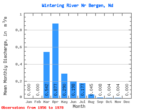
| Statistic | Jan | Feb | Mar | Apr | May | Jun | Jul | Aug | Sep | Oct | Nov | Dec | Annual |
|---|---|---|---|---|---|---|---|---|---|---|---|---|---|
| Mean | 0.00 | 0.00 | 0.54 | 0.88 | 0.29 | 0.20 | 0.18 | 0.04 | 0.01 | 0.00 | 0.00 | 0.00 | 0.18 |
| Standard Deviation | 0.00 | 0.00 | 0.78 | 1.54 | 0.59 | 0.38 | 0.49 | 0.18 | 0.03 | 0.01 | 0.02 | 0.00 | 0.18 |
| Min | 0.00 | 0.00 | 0.00 | 0.00 | 0.00 | 0.00 | 0.00 | 0.00 | 0.00 | 0.00 | 0.00 | 0.00 | 0.00 |
| Max | 0.00 | 0.00 | 2.52 | 5.36 | 2.34 | 1.47 | 2.25 | 0.83 | 0.10 | 0.07 | 0.09 | 0.00 | 0.68 |
| Coefficient of Variation | 1.44 | 1.76 | 2.05 | 1.90 | 2.77 | 3.94 | 3.21 | 3.46 | 4.47 | 4.69 | 1.03 |
 Return to R-Arctic Net Home Page