|
|
|||||||||||||||||
| Point ID: 9640 | Downloads | Plots | Site Data | Code: 05120200 |
|
|
|||||||||||||||||
| Download | |
|---|---|
| Site Descriptor Information | Site Time Series Data |
| Link to all available data | |
| View: | Time Series | All |
| Units: | m3/s |
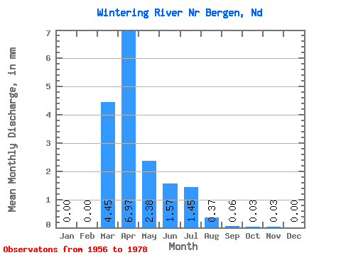
| Statistic | Jan | Feb | Mar | Apr | May | Jun | Jul | Aug | Sep | Oct | Nov | Dec | Annual |
|---|---|---|---|---|---|---|---|---|---|---|---|---|---|
| Mean | 0.00 | 0.00 | 3.19 | 4.99 | 1.70 | 1.13 | 1.04 | 0.27 | 0.04 | 0.03 | 0.02 | 0.00 | 12.18 |
| Standard Deviation | 0.00 | 0.00 | 4.59 | 8.77 | 3.49 | 2.14 | 2.88 | 1.04 | 0.14 | 0.09 | 0.10 | 0.00 | 12.50 |
| Min | 0.00 | 0.00 | 0.00 | 0.00 | 0.00 | 0.00 | 0.00 | 0.00 | 0.00 | 0.00 | 0.00 | 0.00 | 0.02 |
| Max | 0.00 | 0.00 | 14.81 | 30.47 | 13.76 | 8.38 | 13.23 | 4.91 | 0.58 | 0.41 | 0.48 | 0.00 | 46.77 |
| Coefficient of Variation | 1.44 | 1.76 | 2.05 | 1.90 | 2.77 | 3.94 | 3.21 | 3.46 | 4.47 | 4.69 | 1.03 |
 Return to R-Arctic Net Home Page